I know I've mentioned here before that I am a new Library and Information Science student at the University of South Florida. Well, currently I am taking one course, Foundations of Library and Information Science. Our instructor adopted a hands-on approach to this introductory class. Her assignments encouraged us to engage with professionals in the field.
One assignment required us to tour two libraries and interview two librarians, one at each library we toured. Since I hope to become an academic librarian, I chose to tour UF's Map and Imagery library. I also interviewed its Map Librarian, Carol McAuliffe. During our interview, she mentioned her belief that usage was up at the Map Library in part due to an increased awareness among students of map technologies such as Google Maps. Ever since she made this comment, I've been curious about online mapping. Thus, "thing" 4 is online mapping.

Thing 4: Online Mapping
(Or: "Where in the World is UC San Diego?")
Online mapping tools have become popular recently because using online mapping allows people to forgo using (sometimes) unwieldy paper maps. Often, corresponding apps can be downloaded and used on smart phones, adding more convenience for users.
One popular online mapping technology is Google Maps. Since this technology was part of my inspiration to explore online mapping generally, it will be the primary focus of this post.

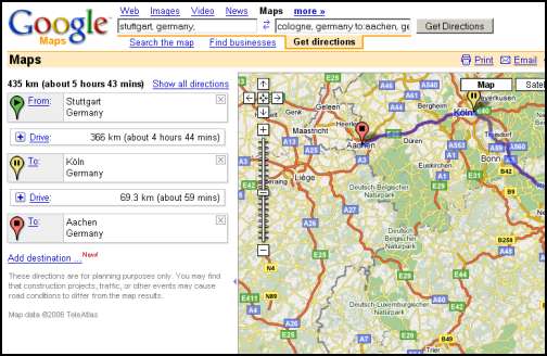
Here is a screen shot of the "Get Directions" feature in action:
One other feature I've found particularly helpful is the "Street View" option. When users use this feature they will see current photographs of the street their destination is on. I've found this feature to be a life saver as I am severely directionally challenged.
If you were looking for the "El Toreador" restaurant in Redmond, WA this map with "Street View" image might be helpful:

Now, to return to UC San Diego. Their libraries, like other academic libraries do make use of some mapping technology to assist patrons. From their main libraries web page, one can search simply for "map" to find driving directions and to find the library within a campus map. Additionally, you can find color floor-by-floor maps with indications of exhibits, collections, and even rest rooms!
My only concern regarding online mapping is that libraries (academic and otherwise) are acting slower than I'd like in embracing the technology. I think online mapping may allow patrons to make the best use of a library's collection!
J
There are a few libraries starting to use Google Indoor Maps. So far, Portland (ME) and Hingham (MA) Public Libraries are live. I've put a few screenshots of public libraries using Google Indoor Maps up for folks to peruse. I'm really excited about this; can you tell?
ReplyDeleteHi Ben! Thanks for your thoughts & thanks for passing along the information about some libraries embracing Google Indoor Maps. I hope more libraries make use of this technology in the future.
ReplyDeleteOne cool thing U of S explored that I haven't yet is a Community Walk (www.communitywalk.com) People can use this site to make their own interactive maps. I think it'd be pretty interesting to see what happens if these two technologies are used in conjunction with one another!
For what it's worth, I also think if a library made use of Google Indoor Maps, the library would be more user-friendly for patrons. That is, Google Indoor Maps could help maximize a library's utility to patrons!